![]()
![]()
Amreya 1
Team leaders : Marie-Dominique Nenna, Valérie Pichot
The Amreya 1 site, also known as Kom of the Quarry, is located on the southern shore of Lake Mariout about 26 km from Alexandria as the crow flies.
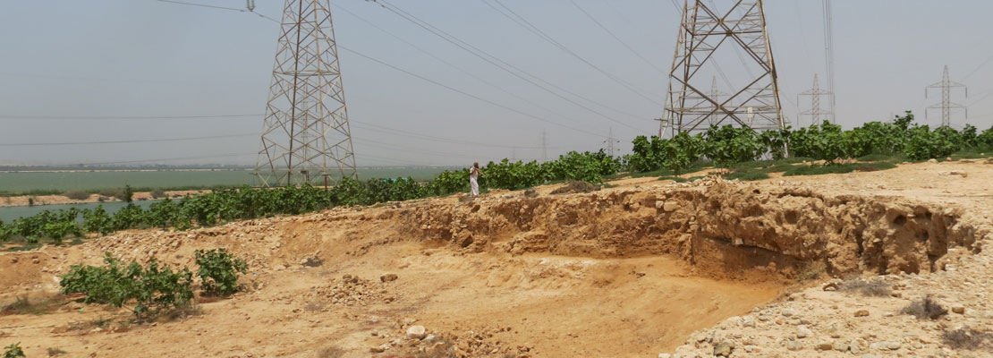
The archaeological site is situated on a rocky promontory, which in the early 1980s still covered an area of 80,000 m2 (400 m east/west by 200 m north/south), about the size of a village.
Since the mid-1980s, the site has undergone a gradual but significant deterioration, and today it covers a surface area of just 18,116 m2 (180 m east/west by 130 m north/south).
The CEAlex carried out a month-and-a-half-long emergency operation in 2015 to save what information was still accessible on the site before it was destroyed. As excavations were made impossible by the presence of high-voltage pylons and a pipeline, we conducted work on the visible stratigraphy (cleaning of sections, surveys and analysis) assisted by photogrammetry. A surface ceramic prospection was also carried out on part of the site, as well as a series of cores in the hypogeum/quarry.
The site was occupied from at least from the 2nd century BC in the Hellenistic Oeriod until the Late Roman Period (7th century AD). Two sherds from the 9th-10th centuries have been found on the surface, indicating that the site was little used during this period.
In the upper part of the promontory, a study of the stratigraphy revealed by the pipeline construction and the destruction of the slopes of the kom indicates a large Late Roman settlement that followed a Roman occupation and a Hellenistic occupation, both of which consisted of mud-brick buildings. Notable structures include the pit of a latrine, the fill of which consists mainly of fish bone fragments and grape seeds, as well as cooking structures (domestic fireplaces) that yielded various types of grains and grape seeds. At the bottom of the stratigraphy is a well, the filling of which can be dated to the 2nd century BC.
In the lower part of the promontory, the stratigraphy created by the destruction of a large part of the kom shows the remains of imposing buildings identified in four main phases of occupation. This sector also revealed a number of highly visible floors and activity levels, as well as structures linked to water management: cisterns, piping and wells.
As for the quarry-hypogeum (Hellenistic and possibly Early Roman), the study of the cores confirms that it was filled with water during the occupation of the site, most certainly in the Late Roman Period, thanks to a significant rise in the level of the lake that has already highlighted in studies on the island of Marea and the Akademia site. However, the question of its possible use as a mooring basin during this period remains open.


Bibliography
M.-D. Nenna, « Les actions du Centre d’Études Alexandrines en 2014-1015 », Supplément au BIFAO 115, 2015, p. 281-291.