
![]()
![]()
Historical cartography
With almost 850 maps recorded for the period from the end of the 15th century to 1950, the historical cartography of Alexandria is particularly rich. Several types of plans were produced both successively and concurrently: cavalier projections, nautical maps, topographical plans, reconstructions of ancient Alexandria, tourist maps, development projects, etc. In 1921, Gaston Jondet published the Atlas historique de la ville et des ports d’Alexandrie which, with its 53 plans, has become a reference work on the subject.
The first cartographic images were cavalier projections, viewed from an imaginary elevated point out to sea. They show a number of buildings that are characteristic of the city and that are mentioned by generations of travellers. The first two representations of Alexandria by Piero del Massaio (with Hugo Comminelli as copyist) were taken from a Latin translation of Ptolemy’s Geography in the 1470s. Then, from the 16th to the 18th centuries, numerous perspective views, or “portraits” of the city, were produced, some with strong similarities: Pierre Belon du Mans (1547), Johannes Helffrich (1566), the geographer Georg Braun and the engraver Frans Hogenberg (from 1575), Olfert Dapper (1668-1686) and Abbé Calmet (1728).
At the same time, nautical charts depicting Alexandria also appeared. Sometimes referred to as portolans, their purpose was to guide sailors by encompassing all the information they needed to navigate the ports. The ten or so representations taken from the Kitâb-i el-Bahriyye (“Book of Things of the Sea”) by the Turkish navigator and cartographer Pîrî Re’îs (1521-1526) are among the most remarkable. Subsequently, other navigators provided representations of the city and its harbours, including Christian Melchien (1699), Marquese de la Garde (1713) and Frédéric-Louis Norden (1737-1738).
In parallel to some of these views, the first two true topographical maps of Alexandria appeared around 1685-1687, produced by Étienne Gravier d’Ortières and the naval hydrographer Razaud, whose mission it was to inspect the ports of the Levant. The new layout of the city can be seen, with the gradual abandonment of the dwellings inside the defensive walls in favour of land on the peninsula to the north of the walls.
After the map produced by the draughtsman Louis-François Cassas in 1785, a new level of precision and detail was achieved with the topographical surveys conducted by the various scientists and scholars involved in Bonaparte’s Egyptian Expedition between 1798 and 1801. Their work resulted in several maps of Alexandria and the surrounding areas. A few years later, in 1809, the Englishman Henry Salt drew up another general map of Alexandria.
During the first part of the 19th century, maps begin to show the urban expansion of the town, following the major works carried out by the viceroy Mohamed Ali. As part of these developments, we should mention the overall maps and detailed plans of the fortifications drawn up in the 1840s by Colonel Gallice, Director of Fortifications.


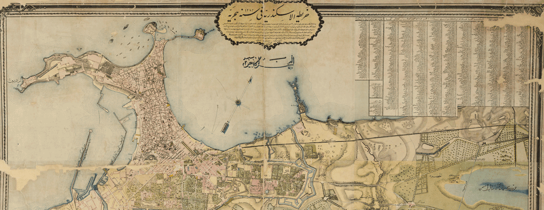
From the mid-19th century onwards, cartographic production increased significantly. After Charles Müller‘s map of 1855, Mahmoud Bey el-Falaki produced three essential documents: modern map of 1865, extraordinary in its precision and the quantity of details recorded and reproduced (with a list of 855 place names); a « Carte des environs d’Alexandrie » and a map recreating ancient Alexandria Mahmoud Bey el-Falaki’s reconstruction is a departure from that published by Pierre Nicolas Bonamy in 1736 and from those that regularly appeared as inserts in 19th-century atlases. A true prototype in the field, this became the source of many other maps thereafter, and it remains a reference model to this day.
Egyptian guidebooks and directories, which began to multiply in the 1860s and 1870s, were another source of maps. These included the famous tourist guides by Baedeker,, Joanne, Murray, Cook, as well as directories published by J. Millie and E. François-Levernay.
After a bilingual Arabic/French map of Alexandria drawn up in 1887 by the Tanzim (municipal roads department), other administrations produced plans in the first part of the 20th century: we should mention the numerous plans, at various scales, of Survey of Egypt and that of the Municipality of Alexandria in 1902.
To conclude this overview of the historical cartography of Alexandria, other types of plans are also worth mentioning: those published in encyclopaedias, those depicting a historical event batailles franco-anglaises en 1801 or the bombardment of the city in 1882), plans for development projects (notably for the work on the Western Harbour). Finally, the collection of insurance plans, drawn up between 1880 and 1950 by Charles Edward Goad, Carlo Marchettini, Hérold Gallo, Kévork Mérametdjian, Noel Dawson, reflects the importance of the cotton trade in Egypt and the activities in Minet el-Bassal district..
In this way, the history of the city from the 15th century to the mid-20th century can be read and deciphered through the maps. The superimposition of ancient maps on a modern vector map of the city enables spatio-temporal studies and contributes actively to the historical understanding of Alexandria.


BIBLIOGRAPHY
G. Jondet, Atlas historique de la ville et des ports d’Alexandrie, Mémoires de la Société Sultanieh de Géographie, 2, Le Caire, 1921.
C. Shaalan, « Mapping Alexandria: a Long History of Change », Alexandria Beyond the Myth – Architectura Archeology Urban Change, L. Ferro, Cr. Pallini (dir.), Araba Fenice, Boves, 2009, p. 7-23.
C. Shaalan, Alexandrie, au fil des plans. Études sur la cartographie d’Alexandrie, milieu du XIXe siècle – milieu du XXe siècle, thèse de doctorat, sous la direction J.-Y. Empereur, Université Lyon 2, soutenue le 11/05/2019.
H. Thuile, Commentaires sur l’atlas historique d’Alexandrie, Publications spéciales de la Société Sultanieh de géographie du Caire, Le Caire, 1922.